
Shortly after my encounter with the nuns, reported in yesterday's post, I crossed Lorraine and continued along Fromont. In the early 1900s it was labelled Chemin de la Patte d’Oie, although Stevens notes on his map that it had formerly been called Fromont. Only a few years later, in a subsequent edition of his Carte de la Forêt de Soignes, he reverted to the older name. As far as I can tell, it has remained Fromont ever since.
You would be forgiven for thinking that Patte d’Oie refers to geese deeper in the forest towards Groenendaal. More likely it describes the branching of paths at the junction with Lorraine, the spread of tracks like a bird’s foot. Then again, perhaps both readings once coexisted.
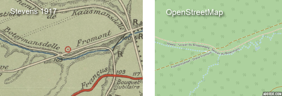
As I approached the junction with Botermans there was a distinct kink in the path. It is visible today, and OpenStreetMap records it, yet it does not appear on Stevens’ map. There the line runs straight.
Stevens does, however, mark the spot with a red circle. He used these to indicate an ancien établissement sidérurgique, a small pre-industrial ironworking site. I will return to these in a forthcoming newsletter.
The path is old. The kink is not. My suspicion is that instability in the ground, perhaps linked to the former ironworks, combined with heavier later traffic, required a modest diversion. A small adjustment in response to what lay beneath.